PHOTOS HERE –>> Up the Rio Dulce, Guatemala or https://goo.gl/photos/n9c9pUZjJMq7x6Ax7
 On July 3rd we were headed to Rio Dulce along with a group of 4 other boats, Dutch, Canadian and American folks we had met in Utila. Why all together? We all needed the same super high tide of the 4th July 06:45 hours in order to pass over the bar that is at the Rio Dulce’s mouth.
This was an over night passage that took us just 20 miles off the Honduras coast. John and I plus the Dutch boat Rafiki gave the reefs off of Utila a wide berth. We had been told that while the charts show depths of 100feet they were not accurate.
Two of the other boats chose to sail into the sun and through the reefs/banks off the Utila coast – why? Because they were foolish and sure  enough one of them hit a reef. They were momentarily on the reef and then, luckily for them released with minimal damage.
The passage for us was more or less a straightforward downwind sail that went well arriving off the coast of Guatemala around 5:00am. The seas had been very rough and it seemed everything inside the boat was thrown around; there was a big mess below. The wind was up to 30knots and blowing into where we were, but we tucked in and anchored off Cabo Tres Puntas ready for our 4th July early morning assault of the Rio Dulce bar.


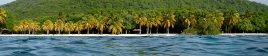
After a restful day and night we arose in time to motor across towards the Rio’s entrance. As it got closer we could see Livingstone the settlement on the side with the entrance to the river behind. Nothing is ever as one imagines. To me the Rio and immediate area looked much larger than imagined.


We had been given way-points, (co-ordinates), of the best line of approach and way to cross over the bar. As we lined up and followed the points the depth got more and more shallow, it was like tucking our tummy  in to squeeze over a fence. The depth went to 0.00 and stayed there with the depth alarm sounding for a good 4 minutes and then it got deeper and deeper again. We were over!

Along with all the boats we set off with. Two other boats that arrived a later and did not seem to follow the same tracks got stuck on the bar, but with a coordinated effort between them freed themselves and did  eventually cross.

Our agent Raul came out to us along with the authorities. It was very easy entering the country all we had to do was hand over our documents and sign a few papers. After about three minutes they left for the next boat leaving instruction to visit Raul’s office for our finalized paperwork.

Livingstone is quite unlike anywhere else we had traveled to, this largely Garifuna town is fascinating in itself. The town Livingstone is called ‘Buga’ – mouth – in Garifuna, for its position at the river mouth.

Unconnected by road from the rest of the country it does however have cars and trucks that have arrived via barges and are just used in Livingstone to drive around the few streets delivering goods. They say that if everyone is on the road in their vehicles at the same time there is a halt in the movement of traffic as the roads are totally jammed. Boat transportation has to be quite good here as it is the only form of transport and you can get up river, to Belize, the cays and Puerto Barrios with a minimum of fuss. We enjoyed walking around exploring the few streets taking in the colourful sites and buying wonderful fruit.

Once our paperwork was cleared we up anchored and headed towards the entrance of the river gorge.

Every hurricane season hundreds of cruisers check into Guatemala and make the trek to the hurricane-safe environment the river provides. This year I am told 1,200 boats/cruisers are somewhere on this river. Now we too were 1 of these cruising boats heading up river.
John and I really feel that few cruising experiences are more stunning than a trip up the  riverfrom Livingston. Cliff walls of limestone 500 feet tall flank the gorge sides whittled away by the Rio’s water flow over millions of years.


Trees of numerous types have taken root on the rocky  cliffs with first one and then the other reaching higher and higher upwards to gain the light of the sun. Thick vines and tendrils from some trees plummet in the opposite direction to the water. On every other tree branch, huge bromeliads and purple orchids spring outward. White herons dot the deep green foliage as they bob lazily on limbs; cormorants air their wings and rest atop sunken logs. It is quiet, but for the sound of the birds singing, breathtakingly beautiful, mystifying and inviting.
 Looking across the water against the dramatic backdrop, you can spot fishermen quietly huddled in their Cayucos (dugout canoes), some others of them standing to throw nets, while others of them are tucked under the bottom canopy of overhanging branches. They lower and raise hand-fishing lines connected to something that will float, a piece of Styrofoam or a plastic bottle. Patiently they wait in the hopes of catching a perch or better yet a Robalo. Then a river taxi will fly by carrying visitors up or down river to their destinations.
 As we slowly made our way up the Rio around the bends and u turns we took photos and videos trying to capture the magnificence of our surroundings. Our journey from the mouth to Texas Bay where we stopped for the night was about 10 miles and took us just over 2 hours, but time seemed to fly as it was quite the incredible journey.


 At Texas Bay we were again surprised by being able to wind our way into a secluded almost lagoon type anchorage – it was like being anchored in a large pond. There we found a number of friends anchored too, Steve and Anna on Bad Kitty and Rian and Rob on their friend Jeff’s boat. Everyone was there for the promised celebration of dinner and fireworks at the Texas Bay bar.

John and I explored in the dingy the surrounding canals and mangrove areas connecting to the main river and tributaries. Again it was just incredibly beautiful, all the different trees, flowers, butterflies, dragonflies, vines hanging down into the water, the water lilies along the surface and all reflected on the water’s surface. For a photographer there is a feast of images!

The indigenous people have dark, raven, hair and the warm caramel skin of the Mayan heritage. When passing their thatched wooden homes that are built on stilts over the water, they are hesitant to openly gesture or gawk. However once you smile and wave in their direction, they respond in kind. The children appear to be very happy playing, swimming and fishing in the Rio.


The sailboat Rafiki that we had traveled with from Utila arrived and together we enjoyed the evening at the Texas Bay bar. As it was a special occasion a pig had been roasted. It was delicious! Fireworks went off in spurts, the local children were totally enthralled by the firework display. It was a great 1st evening on the Rio.

 Off we went the next morning, from Texas Bay the journey changes as you cross El Golfete a 9 nautical mile long lake. The morning we crossed the lake was a perfect sailing breeze/wind. So up went the jib and off we sailed smoothly across the flat surface of the lake. Just incredible to think we were way inland in Guatemala sailing across a lake.

 Towards the end of the lake we curved in our passage around a few islets, down a dogleg and arrived in Rio Dulce marina zone. The marinas are on both sides of the river with the large Rio Dulce Bridge with the town of Fronteras at the end and El Relleno at the other. Under the bridge and on the other side are several more marinas and finally Lago de Izabal/Lake Isobel.
 We chose to anchor in Ensenada Nana Juana, which is the area where several of the larger marinas – RAM Marina and yacht club and Nana Juana – can be found. Our reasoning was that we needed to check the area and the marinas before we decided where to base our
selves. We had been advised by friends about the different marinas, but we needed to see for ourselves if there was one that would suit Chico, plus have faculties for Ethan and Rhianna who were soon to arrive for a month.

 Off to visit the town we went and what a surprise it is when you first arrive. The town of Fronteras AKA Rio Dulce lives up to its name and is a real “frontier” town with stalls selling every imaginable item, spilling over the pavement and into the road. Along the narrow roadway, (just 1 lane in each direction with plenty of potholes), travel giant articulated trucks, jostling with little 3-wheel “Tuc Tuc” taxis, bikes loaded with 4 plus passengers,
 old cars and mini vans serving as collective buses. The stereos blare music, and there are people of
  every type everywhere. It is a town that is always entertaining to visit, as there is just so much to watch, really anything and everything could and
  does happen in Fronteras. John and I were well impressed. What a vibrant place to spend several months!
Next we visited several marinas along the river. There are stores, restaurants and marinas, which can only be reached from the river. We were impressed with all the marinas we visited. The marina we had previously been thinking of staying at was  on the other side of the bridge. We decided that there was just no chance of a breeze in that area, many of the others seemed to have masses of mosquitoes, which I am reluctant to have around if avoidable. We chose Catamaran Hotel and Marina as our base.


 Catamaran Hotel and Marina is just wonderful! Our
  friends Gillian and Gordon off N’Aimless had recommended this marina and it really is the best one for us. We have a side tie, it’s quiet, with lovely gardens, a pool that is partly shaded in the afternoon, a bar, restaurants, cabanas over the water and most importantly is safe for Chico to wander around, (all for only $200 a month).


 John and I also dinged to town and walked to and over the Rio Dulce bridge one morning. Which incidentally,
 I believe the US Army Corp. of Engineers were contracted to build. They did a magnificent job. The view from the top is spectacular looking down and out across the Rio in both directions. Of course, in true Guatemalan fashion, vendors have set up shop at the top selling all sorts of drinks and eats. Tour buses and cars stop for tourists to take
  photos. Can you imagine the authorities allowing that on a freeway or motorway bridge? We loved the views and happened upon Steve and Anna strolling across the bridge too.

Meanwhile John had employed 3 fellows to polish the stainless steel on Aeeshah. These young men were very inexpensive to hire, worked for less than 2 full days, polished the stainless until it was like brand spanky new. Even the inside of the barbecue was shining like new. It was just amazing!

Before we knew it the time had arrived to travel to Guatemala City to meet Rhianna and Ethan arriving July 18th.
“The pessimist complains about the wind; the optimist expects it to change; the realist adjusts the sails.” – William Arthur Ward
“If you are lucky enough to find a way of life you love, you have to find the courage to live it.” – John Irving


 We moved the next morning to
  that the holding was not good – he had dragged. Sure enough later in the afternoon just when the wind blew up to 39knots our anchor dragged. It was action stations, me on the bow in the wind and rain getting the snubber off the anchor chain, John at the helm trying to keep us into the wind. He said it was tough as the wind really had us and we were just whipping along sideways. Anyway we got ourselves re-anchored and secure again, we hoped.


 The shoreline beyond the bridge is rugged as the waves pound ashore there. We could see that there were many new homes being built. They looked to be for the upper income bracket, and still appeared to be on the
  market. A nice place to live but very exposed to the weather.

 It is said that Robinson Crusoe was ship wrecked on Utila and that that is where the story comes from, so Utila is known as the Robinson Crusoe Island. Anyway our walk to Pumpkin Hill turned out to be a track through marshy, forested farmland. And before long we had


 island, Pumpkin Hill.


 teen girl Andeara and her granddad, Pedro with us.


 anchored in an anchorage sheltered by the reefs and a few cays. The only land access was through the Marina, but for $2:00 a day we also had the benefits of the Marina, trash dumping, transport to the grocery store and such. Lucky for us the day after we arrived was the day the vegetable/fruit man came, plus the transport to Eden’s the grocery store. T
 English mustard, HP sauce, marmite, red Tai curry, all the little luxuries were available. In fact we returned a second day too for more groceries and are now fully loaded again and prepared for Ethan and Rhianna’s visit.
 We explored the area in the dingy
 back of homes and smelt of sewage. Just as we decided it was too shallow we got something stuck on the prop. Luckily there was a dad and his son outside their home and they leant us a knife cause it turned out to be a T-shirt, probably theirs, stuck around the prop. Anyway the canal was ruled out as access to French Cay Harbour.


 West Bay
 had to go through a narrow channel in the barrier reef.

 ‘town’.


 Harbour. On this cay they have built a
  John was quite skeptical concerning a dreaded biting insect, until he by the second day, was covered in large, very itchy, uncomfortable bites. Normally I am the one that the mosquitoes and no-seeums feast on, but not this time. Our neighboring boat, Landmark, with Colin and Anne were also eaten by this bug. They said it looked like a small flying flea like bug; I never saw it and luckily never suffered its bites.

 and print a
  picture of Aeeshah, we could only print in black and white though. Meanwhile having found an ATM, for cash, a internet place that sold SIM cards, plus the grocery store that did copies of our documents, we returned to the Port Captain. Picture was – “no good, need colour print! Go to Internet place and print a colour print.” Soooooo, off we go, get the colour print. By then it was later in the afternoon, I was shattered from lack of sleep, we were both well fed up. We get the colour print, go back and “no! Picture no good! Need picture of boat here!” Then he announces that he is off to measure a ship, so by then I/we had had enough, I left the colour print on his chair and we headed back to Aeeshah.
 were perfect, we could go anywhere,


 colourful restaurant on the hill across from the anchorage. Anne and Colin came with us; we landed the dingy on a dock, walked the steep hill to Mia Casa Too and found it to be just lovely. It is very brightly, but discreetly decorated with solid wooden furniture, a wide balcony with looks right out over the anchorage and Harbour. There is a wonderful breeze and the music is great. I had


 that it was occupied. The couple was the caretaker and his sister, they invited us in
 then to the top of the
 We enjoyed the view, had a snack and water and set off down for a challenging downward climb. The views were worth it, the scenery was lovely, but it was very, very hot.


 Hobbies Cays
 This passage was a


 John went for a rest as he had been up much of the night while I tidied up. Around 10:00 Bad Kitty showed up and then an hour later Landfall arrived.

 standing up straining to look for the adult birds for food.


 On route to Providencia we were sailing with
 rods, Jen to attend to Chico and the wheel. It looked to be 2 great fish, but unfortunately the 1st broke the line and the 2nd slipped the hook. Chico looked at John with a very disdainful look. Meanwhile Colin on Landmark was “shooting” the boat and fishing. Then just before we started to head in
 Meanwhile back to
  right along the shoreline where a there is a well laid path of pavers decorated with symbols of plants.
 To one side you look out over the shallows to the
  ranging from traditional wooden to new concrete design. Most homes being gaily painted with pretty gardens, others being more the working home of the fisherman or the laundress. Between the homes run pathway
  towards the hills or mangroves areas with crabs and lizards scuttling around. It was a lovely walk, but being the afternoon it was hot as in the direct sun with little shade.
 shade below the statue with the lovely breeze that was blowing and admired the magnificent view of 360 degrees. It really is a spectacular island. Above the statue was the remains of Fort Aury. We clambered up the hillside to the cannons, which were pointed out over the Harbour and agreed it was too hot to venture any further along the pathway.

 the mangroves. Again the pathway was interesting, at the end we found a sign telling us it was the site of where
 Morgan’s Head.


 was much algae which we assumed meant the water was just too still and hot. We headed around Isla Catalina in the dingy rounding the whole island on our way back to the boat. It is a very photogenic area.
 we hired a mule.
 later that all the bus stops are of unique design). This also was the entrance to one of the popular beaches. We walked down to the beach where we found a hut and some locals selling local music and
  trinkets. We ended up buying a CD and a pair of Lionfish fin earrings, which are quite unusual. The beach was empty but looked to be a popular spot. The 2-story hut was the home of the entrepreneur who lived there supplying drinks and trinkets to visitors. This structure was quite a colourful
  structure made from what looked like painted driftwood.
 Next stop was for mid morning coffee for the coffee drinkers. We found a
 horseracing beach.
 We drove on and found ourselves at the other end of
 Roland the owner was lying in
  his hammock swinging comfortably behind the bar. He saw potential customers and quickly jumped from his hammock and into action.

 various owners had taken much pride in their property.

 was morning the walk was far cooler and we passed the
 dropping ripe mangoes. John was thrilled to be able to pick up and eat ripe mangoes as he walked. On the return journey we collected a pile of mangoes, which we later picked up, from the beach where
 we stacked them.

 After lunch that day we
  snorkeling was good in areas and then disappointing in other areas. Unfortunately there is much coral bleaching and there looks to be large areas of damaged reef, maybe by boats.
 Our friends Colin and Anne had directions
  home on Isla Catalina.
 regular trail through the trees. It was an excellent walk.
 coast and then tracking uphill along an old stone walkway that was well overgrown to a wreck of what must have once been a splendid house on the hill. The property over looks the bay below and the whole island, but being so overgrown what once must have been excellent views were now glimpses through the trees. I would say it
  was a 2 story home with evidence of at least 2 bathrooms, an outlook from the roof area and a
  living/kitchen onto porch space, plus there was a pool. It
  We collected mangoes on the way back to make mango chutney. The trail had again been one with
  dozens of mango trees with hundreds of ripe mangos. John was in mango heaven!
  Our last day in Providencia we went with Colin and Anne plus
  two other couples to
  he has the most horses on the island and his horses are some of the racers.

 We started at the trailhead with Hawkins
 Hawkins was a brilliant guide;
 it wasn’t too hot. We wound our way to the top, which as expected had an
  If it had been a sunny day the view would have been stunning, but it was pretty special anyway. Hawkins is at present
  reestablishing another way to head back, but for now we had to head back the same way. Making the whole trek

 Our time was spent
  up supplies so this required a 2 hour bus ride to get to a
  could also carry piles of groceries and crates of beer.
 container into liter plastic bottles the desired amount of fuel, be it gasoline, diesel or what ever. This is on the porch, the fuel containers/barrels are kept in the front room of the house where you will also see babies being cared for, children, TV playing and life going on as normal. Just another day in Panama!
 white beach we were surprised by a small strip of sand under the trees with houses above and cows grazing. It’s never as you imagine.
 Finally John felt we could head off, probably having to motor for the first part, but leave we did.
 motoring, and the seas were a bit steep, but we were finally off. The first 24 hours were fine, we even


 miles and part of a small group of cays. It has an English history that started with the Puritans who were also involved in New England. There is a history of piracy, Henry Morgan being just one notable pirate to hide away there. There is a short Spanish history in Colonial times, then settlers from other Caribbean islands also settled including many former slaves from Jamaica. Plus the island has been part of the


 duty free shops. I prefer the older part of town where the shops are small and jammed pack with any type of thing you might need. This is where you find the locals shopping, the bargains and the excellent fresh fruit. We even saw the famous


 that are up on
 those rocks and reefs so guessing there must also be many boats lost on these shores too. The beaches along this shoreline are
  of the beautiful beaches along the way.


 rest of the day was spent finding necessary parts for Steve’s water maker and picking up our heavier supplies like crates of beer to stock up the boats. All in all we had a fun day!
 We had not been able to see the famed
 miles in the hot sun we found the hill. Up we climbed passing a very untidy neighborhood, trash everywhere, stray dogs, cats, kittens, and kids. A totally different side of the neat and tidy San Andres of the shoreline roadway. Maybe this is why the mule/golf cart can’t go up there.
 Finally reaching the top we went along a little bit further


 Gavin and Katie’s daughter
  around. She is incredibly interested in everyone and everything.
 Such a inquisitive, lovely, cuddly, baby girl. We visited as much as we could wanting to spend as much time with Lily as possible.
 In Bermuda Good Friday is a special day.

 materials.
 Other important traditions, which we enjoy, are


 have a wonderful day together.


 The next day while at my son’s house we had a phone call from Westmeath where my Dad is a resident/patient. My Dad had fallen and had a bump on his head, would we come and have a look and take him to be checked.
 bad for some years now, but that day it was very bad. Plus he kept repeating certain behaviors.


 Gavin and Katie’s new boat
 We went towards
  conditions were beautiful with wonderful reflections upon the water.


 Walks with our dogs:


 grave is situated in St James Churchyard
 of the surrounding graves are also of extended family members. It was a Sunday and so we could hear the service going on inside the old church. The churchyard is quite a lovely one with huge cedars of 100s of years old.
 public dock
 out of Dockyard and
  Gavin
Gavin
 was wonderful!! And then it was time to return to Aeeshah.


 points almost a vertical assault. What had happened
  over the few hundred years since the battery had been built was erosion of the hillside. It was now a
  gorge, where one has to climb the sides. It is a pretty hike as the steep hillside is grassy and looks out over the entire bay. We reach the battery but it is in disrepair so to climb into it one needs to enter the moat and climb the walls. Not looking safe we gave that a skip. Plus I had learnt by then that all kinds of wasps live in nests in such walls and they do not like to be disturbed.


 originally being brought to the top of the ridge those hundreds of years ago?


 1st John explored the upper fort again, climbing its walls and checking the view.

 Then into the jungle we went. We found this path again more or less followed a ridge. I think the property line –barbed wire fence – that had been erected created it. It was wonderful hiking through the enormous trees, again listening to the birds. Sometimes we actually saw the birds, but most time they are well hidden in the foliage. We did see
  plenty of interesting insects and spiders. John being the “leader” was plagued
 by spiders and their webs, guess that comes with being the leader. We could hear the Howler Monkeys off in the distance and really hoped to see them, but never did. Well we hiked about an hour and a half trying to reach the other end, wherever that might be just to reach basically a dead-end. We could have bush-wacked our way onwards, but felt in the heat, with less than half our water left we should head back. The journey back took just 45 mins.
 Linton Bay Marina


 Once we were in the marina we were able to enjoy our bikes. Sorren too has a bike so we set off to see what we could find.

 (mind you I usually push it up the steep hills). We passed the Panamarine entrance, continued on to a small fishing settlement,
 Jose del Mar,

 Isla Grande
 shoreline which goes from one end of the island to the other.
 Heading east we enjoyed the quaint shoreline buildings. They were all colours with multiple decorations from shells to tiles to make each distinct in its own right. The islanders obviously take pride in their properties. There was no trash, which
  was a refreshing change from the mainland.
 Having reached the pathway heading up we assumed correctly it lead to:
 up we climbed to the top.
 Reaching the top, I kid you not,
  headed down. We then set off along the same path back the way we had walked and then
  onto the other end of Isla Grande. I was very scenic and easy to see why it was so popular with the local tourists.
 Catching local busses
 region it requires traveling to the nearest ATM. This is a over an hour in a bus, usually two hours, or an hour in a fast taxi. The least expensive is a bus ride for $2.00 as opposed to maybe over $40.00. Off on the bus we had to travel several times.
 the local busses. An experience that everyone should try. The busses are old USA school busses which were left when the Americans left Panama. Each driver has decorated the busses according to his taste, (never seen a female bus driver yet). He drives as he feels speeding up to super faaaassst then for no apparent reason creating along veeerry slowly. Our 1st bus had
  outsides are normally decorated with extravagant
  pictures usually including Christ, I guess as a Blessing. The music again is up to the driver’s taste. This can be mind blowingly loud and ugly as in our 1st bus ride or wonderfully rhythmic Spanish tunes. One is lucky to get a seat as the busses are normally full, so try to catch them early. The locals are all
  very friendly and the atmosphere on the bus is one of terrific endurance. Our
  trips took us to
 Panama City
 Panama City.

 We visited the
  and enjoyed wandering around looking at the old architecture.
 and reduced most of the city to ruins. A new city was built nearby at Cerro Ancon in 1673 where today the old quarter is closed to traffic and very pleasant to wander around the old streets.
 We found a fantastic Yogurt cafe where you could choose any flavors of yogurt, all natural and healthy, then put any types of toppings on your yogurt. There we had a wonderful refreshing treat!


 American business center.
 There are the world’s tallest residential buildings – over 100 floors – other skyscrapers of very interesting design make an interesting skyline.

 We went back to Nargana to get some water
 Saturday many of the Nargana town folks were also headed up the river off to get water and for the ladies to
  do their laundry. Heading up the river is just lovely, the jungle is beautiful, the bird noises are incredible, seeing them is not easy unless they are brightly coloured. Butterflies and insects fly all round and the water is so clear you can see the river fish. Once upriver we went
  upstream from those doing laundry and having a wash and decantered
  our water. It was a fun expedition.


 countryside is very lovely.
 Shelter Bay Marina
 using wifi and laundry at last, and going for bike rides and outings.
 we saw tiny spider monkeys leaping
  across the lane from tree to tree. There were virtually no others along the lane and riding under the jungle canopy is lovely even in the high 80s. The beach where we stopped was completely deserted and we had a very nice walk along it. I was particularly happy to find many great shells, cowries and tulips to name a few.
 Another bike ride we took was
  the observation tower in the jungle
 many birds and insects but seeing them is really difficult unless they are brightly coloured they are well camouflaged in the dense jungle canopy. We arrived at the end of the trail and found no tower. However you could see out somewhat over the jungle. We later found out the platform, built by the Americans had been there 20 years ago but like
  much of the American base it has returned to the jungle. The park service just keeps the trail open now.


 Embera Village visit.
 a visit to an
 of Panama. During the colonial era they proved to be a valuable ally of Maroons, such as Bayano and Felipillo. The legacy of the symbolic relationship is still alive and well in the upbeat tempo of their music, product of the African drums. Embera people are the only indigenous people in Panama
  that have the drum as a part of their musical instruments.
 We were taken by
  ride to and along the shores of the
 craftwork was displayed.
 and set ablaze at the end and the cooking pot is put on top. It is a very hard wood and lasts several weeks before they need new logs.
 What was most interesting to me was their history. They lived originally in the region where the Gatun Lake is now found. When it was decided to build the canal it was necessary to flood the area thus creating
  what is now the huge Gatun Lake. Around the lake was to be all
  warning. They were told they could continue to live in the area but could no longer hunt the deer or wildlife, nor could the farm
  their rice and other crops. So the Embera peoples decided to adapt to the new lifestyle. They create their wonderful crafts, trade, and
  work in nearby communities while still
  following their original culture. Asking about their matrimonial “system” it was explained that no two from the same village or community can “marry”. The leader said
  he set off at 14 crossed the country and found his wife in the village we were in. He then had to prove his worth by building a home and establishing himself before she would become his. Quite progressive thinking I think.
 very tasty, cooked banana and plantain all in a banana leaf cone.
 plus allowed to wander around the village. Watching the children was a highlight. They are
  very innocent and so very lovely.